Escursione dei masi di Cortaccia
Südtirols Süden
-
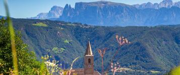
 Cortaccia sulla Strada del VinoFoto: Südtirols Süden
Scoprite i vecchi masi di Cortaccia e la loro storia tramite una camminata attraverso lo storico borgo vitivinicolo. Imparate che cosa significa "Schnoatstall", dove era il carcere di una volta o chi ha abitato nelle case di "Nocker"! Le informazioni sono accessibili via la QRCode sul cartello dell'edificio. Il giro entero dura ca. 2 ore, può però essere accorciato a volontà.
Südtirols Süden
Tipo di strada
Mostra il profilo altimetricoDirezioni da seguire
Punto di partenza: Centro del paese di Cortaccia
Percorso: L’escursione dei masi inizia nel centro storico di Cortaccia e si sviluppa come percorso ad anello attraverso il paese del vino. L’itinerario passa accanto alle storiche residenze e ai masi del paese, per poi salire nei vigneti sopra Cortaccia. Successivamente il sentiero attraversa il paesaggio rurale circostante, caratterizzato da orti contadini e corsi d’acqua, fino a rientrare nel centro del paese. L’intero percorso dura circa 2 ore e può essere accorciato a seconda delle esigenze.
Punti di ristoro lungo il percorso: Ristorante Schwarzer Adler, Cantina Kurtatsch, Gasthof Terzer.
Da non perdere: Residenze storiche e masi, residenza Altlehen, vigneti di Cortaccia, vicoli storici del centro, orti contadini, corsi d’acqua e panorami sulla Bassa Atesina.
Lo scotano: foglie rosse per proteggersi dal sole
Nuova pelle per i serpenti
Lucertola muraiola: non prendetela per... la coda
Museo Uomo nel tempo
Chiesa parrochiale S. Vigilio
Freienfeld Menhir
Come si formano le rocce